Scanned items: Postcards from My Collection
This Category: Corley Mtn Highway Related, has a total of 10 images, as of 21.02.2023 (21:51:32).
Most Recent added/changed image is on top.
Most Recent added/changed image is on top.
Media Info Last Updated:
12.07.2020 (10:50:47)
Title (on) Image:
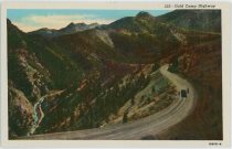
Gold Camp HighwayPhotographer [Date]:
Date Guestimates, Earliest:
Date Guess, No Later Than:
Published By:
Sanborn Souvenir Co.Source ID, My Collection:
P-03800 [#6462]
Shareable Link to PC Info:
www.cripplecreekrailroads.com/04library/scnd_postcards_all.php#6462Description:
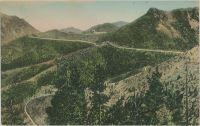
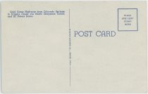
[B] Gold Camp Highway from Colorado Springs to Cripple Creek via North Cheyenne Cañon and St. Peters Dome.
Sorting Categories:
Corley Mtn Highway Related Short Line Related Mining Enties visible:
I've seen copies of this Card sell at eBay on/for:
24.06.2019 at USD 0.5Media Info Last Updated:
19.08.2018 (08:16:00)
Title (on) Image:
Higest Point Corley Highway Altitude 1050 Ft and Pikes Peak. [3]Photographer [Date]:
William Henry Lehr [aka Bill Lehr]Date Guestimates, Earliest:
1929; The License Plate has 'Colo 1929' at the bottom, so it can't be from before that year.Date Guess, No Later Than:
Published By:
Source ID, My Collection:
P-03864 [#6540]
Shareable Link to PC Info:
www.cripplecreekrailroads.com/04library/scnd_postcards_all.php#6540Description:
Yet another version/copy of this not that interesting buy, but way better than my first copy of this scene along the Corley Mountain Highway, or Gold Camp road as it is known as in the modern time live in. This copy is not as sharp as my second version, as it is not as easy to read the date of 1929 on the License Plate on the automobile… The scene is said to be the highest point along the Corley Mountain Road, mentioning Pike's Peak which I then assume is in the background. But other than that, where along the former Short Line, re-used as the Corley Mountain Highway, a toll-road, I can't tell as I only been on the Gold Camp Road towards Cripple Creek one time in my life, and I can't recall a scene like this, but then again, we drove towards the District, I think this view is taken north-east and would have been in our rear-view mirror and hard to make out location of as a memory of a view I hardly can recall.
Sorting Categories:
Corley Mtn Highway Related Mining Enties visible:
I've seen copies of this Card sell at eBay on/for:
11.06.2018 at USD 0.2Media Info Last Updated:
19.08.2018 (08:10:09)
Title (on) Image:
Higest Point Corley Highway Altitude 1050 Ft and Pikes Peak. [2]Photographer [Date]:
William Henry Lehr [aka Bill Lehr]Date Guestimates, Earliest:
1929; The License Plate has 'Colo 1929' at the bottom, so it can't be from before that year.Date Guess, No Later Than:
Published By:
Source ID, My Collection:
P-03776 [#6436]
Shareable Link to PC Info:
www.cripplecreekrailroads.com/04library/scnd_postcards_all.php#6436Description:
Another not that interesting buy, but way better than my first copy of this scene, as on this copy of this view I found it to be much sharper around the car and I got to see a what appears to me to be a date of 1929 on its License Plate! The scene is said to be along the Corley Mountain Road, mentioning Pike's Peak which I then assume is in the background. But other than that, where along the former Short Line, now the Corley Mountain Highway, a toll-road, I can't tell as I only been on the Gold Camp Road towards Cripple Creek one time in my life, and I can't recall a scene like this, but then again, we drove towards the District, I think this view is taken north-east and would have been in our rear-view mirror and hard to make out location of as a memory of a view I hardly can recall.
 I also played around coloring the view using some automatic coloring program, and then play around with that again to the create the painted/colored view, just for fun!
Extra Image Links:
⊞ Higest Point Corley Highway Altitude 1050 Ft and Pikes Peak. [2] {Large Pixels 600dpi; Enhanced} Sorting Categories:
Corley Mtn Highway Related Mining Enties visible:
I've seen copies of this Card sell at eBay on/for:
21.05.2018 at USD 0.09Media Info Last Updated:
19.08.2018 (08:09:45)
Title (on) Image:
Higest Point Corley Highway Altitude 1050 Ft and Pikes Peak. [1]Photographer [Date]:
William Henry Lehr [aka Bill Lehr]Date Guestimates, Earliest:
1929; The License Plate has 'Colo 1929' at the bottom, so it can't be from before that yearDate Guess, No Later Than:
Published By:
Source ID, My Collection:
P-03670 [#6327]
Shareable Link to PC Info:
www.cripplecreekrailroads.com/04library/scnd_postcards_all.php#6327Description:
Another 'why on earth' buy, especially that feel become strong when I scanned the card and got to see how out of focus and shaky looking, unsharp view this turned out to be! Make me glad I got another copy of this card later, hope that will be a better one of this scene. This scene is said to be along the Corley Mountain Road, mentioning Pike's Peak which I then assume is in the background. But other than that, where along the former Short Line, now the Corley Mountain Highway, a toll-road, I can't tell as I only been on the Gold Camp Road towards Cripple Creek one time in my life, and I can't recall a scene like this, but then again, we drove towards the District, I think this view is taken north-east and would have been in our rear-view mirror and hard to make out as a memory.
 07.08.2018 -> Scanned another copy of this view and that was much sharper around the car and I got to see a date of 1929 to its License Plate.
Sorting Categories:
Corley Mtn Highway Related Mining Enties visible:
I've seen copies of this Card sell at eBay on/for:
Media Info Last Updated:
23.07.2018 (14:53:13)
Title (on) Image:
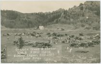
Cripple Creek & Victor Elk's Pinic Clyde Sunday August 6th 1933Photographer [Date]:
William Henry Lehr [aka Bill Lehr]
[06.08.1933]
Date Guestimates, Earliest:
Date Guess, No Later Than:
Published By:
Source ID, My Collection:
P-03662 [#6319]
Shareable Link to PC Info:
www.cripplecreekrailroads.com/04library/scnd_postcards_all.php#6319Description:
Not that much to say here, what ever I can say is already written at the front of this card, that it is a Picnic scene, taken at Clyde along the Corley Mountain Highway, back in August of 1933. I think the Fish Lakes are in the background left, making this north of the road if I am not fully screwed up in my directional sense. Photographer Lehr stands possible beside the road when he took this image?Extra Image Links:
⊞ Cripple Creek & Victor Elk's Pinic Clyde Sunday August 6th 1933 {Large Pixels 1200dpi; Enhanced} Sorting Categories:
Corley Mtn Highway Related Mining Enties visible:
I've seen copies of this Card sell at eBay on/for:
Media Info Last Updated:
03.07.2018 (11:34:49)
Title (on) Image:
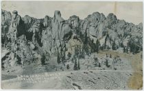
Cathedral Rocks. Corley HighwayPhotographer [Date]:
William Henry Lehr [aka Bill Lehr]Date Guestimates, Earliest:
Date Guess, No Later Than:
Published By:
Source ID, My Collection:
P-03716 [#6373]
Shareable Link to PC Info:
www.cripplecreekrailroads.com/04library/scnd_postcards_all.php#6373Description:
Card is sadly not a good quality card, as it has issues with not being all sharp, quite blurred in the distance left for instance, also it has quite the staining on the right-hand side of the card of what appears to be water damages. Scene is in Cathedral Park, along the Corley Mountain Highway, the former Short Line Railroad Grade, photographed at the filling that replaced the trestle (Bridge no. 30-A), that used to be here till some unknown date prior to 1911 when it got filled in and used almost a decade more before the whole roadbed turned into a Toll Road, and later into the Gold Camp road of today.
Extra Image Links:
⊞ Cathedral Rocks. Corley Highway {Enhanced} Sorting Categories:
Corley Mtn Highway Related Short Line Related Mining Enties visible:
I've seen copies of this Card sell at eBay on/for:
07.05.2018 at USD 2.0Media Info Last Updated:
03.07.2018 (10:52:11)
Title (on) Image:
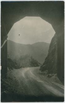
View Out of Tunnel Along Corley Mountain Road, Former Short LinePhotographer [Date]:
Date Guestimates, Earliest:
Date Guess, No Later Than:
Published By:
Source ID, My Collection:
P-03690 [#6347]
Shareable Link to PC Info:
www.cripplecreekrailroads.com/04library/scnd_postcards_all.php#6347Description:
This was marked on the backside as being between Divide and Cripple Creek, but that is just wrong info as this is a tunnel along the former Short Line Railroad, here part of the Corley Mountain Highway Toll-road. I dare not say which tunnel as mind is refusing to work that well… What I can say is that a near identical image appears as a front to a book by Doris Wolfe named 'The Gold Camp Road' on the 'Revised Edition' of this 'Photo-Guide Book' about the former Short Line railroad grade, hence why I know the text on the postcard is wrong!
Extra Image Links:
⊞ View Out of Tunnel Along Corley Mountain Road, Former Short Line {Enhanced} Sorting Categories:
Corley Mtn Highway Related Mining Enties visible:
I've seen copies of this Card sell at eBay on/for:
Media Info Last Updated:
26.06.2018 (07:50:13)
Title (on) Image:
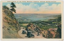
Point Sublime on the Corley Mountain Highway, Colorado Springs, Colorado.Photographer [Date]:
Date Guestimates, Earliest:
Date Guess, No Later Than:
Published By:
The Puffer Mercantile Co.Source ID, My Collection:
P-03801 [#6463]
Shareable Link to PC Info:
www.cripplecreekrailroads.com/04library/scnd_postcards_all.php#6463Description:
This is a scene that seems to have been somewhat 'doctored' for this card as the road appears a little bit flawed in the scale and such, here at the old roadbed of the Short Line, now known as the Corley Mountain Highway, a Toll-Road using the old railroad grade, and here shown how Point Sublime was presented as a road view. The Plains are visible in the background, view is similar to many of the earlier known Short Line R.R. views, most likely that was the idea as well.Sorting Categories:
Corley Mtn Highway Related Mining Enties visible:
I've seen copies of this Card sell at eBay on/for:
04.06.2018 at USD 0.5Media Info Last Updated:
27.04.2018 (05:54:12)
Title (on) Image:
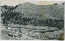
Corley Fish Lakes Corley HighwayPhotographer [Date]:
William Henry Lehr [aka Bill Lehr]Date Guestimates, Earliest:
Date Guess, No Later Than:
Published By:
Source ID, My Collection:
P-03580 [#6225]
Shareable Link to PC Info:
www.cripplecreekrailroads.com/04library/scnd_postcards_all.php#6225Description:
This is a scene unknown to me from along Corley Highway, which I assume means Corley Mountain Highway, or in more modern days, the Gold Camp Road, which to me is still the grade of the Short Line Railroad. I think this might be at Clyde, but this and another view I did not win was the first time I seen views like this, so I can't tell for sure if those dams I see north of the Gold Camp Road at Clyde is those pictured here on this card, but to my eyes, using Google Maps with the Satellite view, and the 3D effect, they sure looks similar so I would say it is the same location, place. That means the road, and former railroad grade, is outside the view to the right in this card view, one would have had to turn right at least about 45-degree to be able to see the former Short Line grade/Gold Camp Road/Corley Mountain Highway in a more distant view.
Sorting Categories:
Corley Mtn Highway Related Mining Enties visible:
I've seen copies of this Card sell at eBay on/for:
Media Info Last Updated:
25.03.2018 (13:53:43)
Title (on) Image:
The Corley Mountain Highway. Colorado Springs, Colo.Photographer [Date]:
Date Guestimates, Earliest:
Date Guess, No Later Than:
Published By:
The Antlers HotelSource ID, My Collection:
P-03354 [#5864]
Shareable Link to PC Info:
www.cripplecreekrailroads.com/04library/scnd_postcards_all.php#5864Description:
This view of the former Cripple Creek Short Line railroad grades is either a ''doctored'' view where the rails has been painted over, or it is an enhanced view of the actually roadbed of the Corley Mountain Highway who ran on the old railroad grade when the railroad was ripped out in the 1920's. Either way, several levels are seen here, with the tunnel no. 6 (furthest left) and tunnel no. 8 quite visible due to the work on the image done by the artist making the base for this postcard.
Sorting Categories:
Corley Mtn Highway Related Mining Enties visible:
I've seen copies of this Card sell at eBay on/for:
![click to enlarge Higest Point Corley Highway Altitude 1050 Ft and Pikes Peak. [3]](http://www.cripplecreekrailroads.com/04library/postcards/p-03864_tbn_higest-point-corley-highway-altitude-1050ft-n-pikes-peak_lehr-3_frmd.jpg)
![click to enlarge backside of Higest Point Corley Highway Altitude 1050 Ft and Pikes Peak. [3]](http://www.cripplecreekrailroads.com/04library/postcards/p-03864_tbn_higest-point-corley-highway-altitude-1050ft-n-pikes-peak_lehr-3_bck.jpg)
![click to enlarge Higest Point Corley Highway Altitude 1050 Ft and Pikes Peak. [2]](http://www.cripplecreekrailroads.com/04library/postcards/p-03776_tbn_higest-point-corley-highway-altitude-1050ft-n-pikes-peak_lehr-2_frmd.jpg)
![click to enlarge backside of Higest Point Corley Highway Altitude 1050 Ft and Pikes Peak. [2]](http://www.cripplecreekrailroads.com/04library/postcards/p-03776_tbn_higest-point-corley-highway-altitude-1050ft-n-pikes-peak_lehr-2_bck.jpg)
![click to enlarge Higest Point Corley Highway Altitude 1050 Ft and Pikes Peak. [1]](http://www.cripplecreekrailroads.com/04library/postcards/p-03670_tbn_higest-point_corley-highway_altitude1050ft-n-pikes-peak_lehr-1_frmd.jpg)
![click to enlarge backside of Higest Point Corley Highway Altitude 1050 Ft and Pikes Peak. [1]](http://www.cripplecreekrailroads.com/04library/postcards/p-03670_tbn_higest-point_corley-highway_altitude1050ft-n-pikes-peak_lehr-1_bck.jpg)
