-> My Collection; The whole book can be seen here as an Image Only Album.
Text and images are slightly different from the other editions using same base text/story line. Also, I procured the coloring of the images, source was Graytoned.
Introduction.
The formal opening of The Colorado Springs & Cripple Creek District Railway, better known as "The Short Line," connecting the tourist center of Colorado Springs with the Cripple Creek District—The World's Greatest Gold Camp—by the shortest feasible route, was celebrated on April 8th, 1901, since which time its fame as a line of unparalleled scenic attraction and marvelous engineering achievement has spread to all parts of the country.
A Gorgeous Panorama.
The ride of forty-five miles from Colorado Springs to Cripple Creek District is one continuous panorama of Nature's most gorgeous mountain and canon scenery, condensing, as it were, the glories of the world within the compass of a two and a half hours' trip.
It starts where the beauty begins, it chooses the most lovely spots as its pathway and seems to lead us to a very high mountain apart, whence we may behold the glories of the world.
A 20th Century Railroad.
The Short Line is a 20th Century railroad in every respect. The roadbed is wide and of an ideal character. The track is standard gauge, of 75-pound steel rails, with broad ties, and ballasted with disintegrated granite.
Equipment.
The equipment is the best obtainable. The passenger coaches are of the best modern standard. They are beautifully finished, richly upholstered and are models of comfort. A special feature of the road is its Observation and Scenic Cars. These have proved most attractive to tourists, affording every facility for viewing the magnificent scenery. The monster locomotives are of the most improved pattern, and built expressly for this service.
SCENES ALONG THE WAY.
Colorado Springs.
Colorado Springs, the starting point of the road, is so well known that few words will be necessary. Its reputation as the tourist center of the Rocky Mountains is established. It is conceded that the Pike's Peak region, which is tributary to it, contains within its borders a greater number and variety of scenic wonders than can be found in any other equal area in the world.
The fame of its health-giving climate is heralded far and near. The numbers of those seeking the benefits to be gained through its influence are increasing rapidly every year, many who come as visitors remaining permanently.
The Start.
Although at an altitude of 6,000 feet, Colorado Springs is in reality a city of the plains. It is at the foot of the Rockies, but not in them. The train has a six-mile run before it swings around to begin its mighty climb. On the left, one mile and a half out, may be seen the immense reduction plant of 300 tons capacity per day of the Portland Gold Mining Company, for treatment of the enormous output of ore from the famous Portland Gold Mine of the Cripple Creek District.
Nearby are the new works of the Telluride Reduction Company with a capacity of 300 tons per day.
Colorado City and Manitou.
But we are gradually ascending. As we rise to the higher foothills and the train winds along their crests, away to the right is seen the towering pinnacles of the rocks of the Garden of the Gods. Farther to the west, nestling in the cleft of the mountains, is Manitou Springs, the Spa of the West, whose healing waters are sought by thousands.
Closer at hand is Colorado City, the first capital of the State of Colorado. In the foreground are the great works of the United States Reduction and Refining Company. This plant for the treatment of Cripple Creek ores has a capacity of 750 tons a day.
Bear Creek Canon.
We are now threading our way along the side of romantic Bear Creek Canon. This is one of the many beautiful canons of this section of the country.
As we reach the base of the mountains the train makes a sudden turn to the left, crosses the canon, and the ascent of the mountains really begins.
The Ascent.
Gradually the scene is unfolded as we rise. We can already see Colorado Springs and the bluffs four miles beyond, and the lake at Broadmoor looks like a silver crescent moon in the dark wooded land below.
Point Sublime.
We are approaching Point Sublime—a spot most appropriately named, for no term could better describe the view which here bursts upon the vision. The charming suburb of Broadmoor is at our feet; Colorado Springs lies to the northeast, and an excellent idea of the city and its extent may be obtained.
Away beyond, fading into the uncertain horizon, stretch the rolling plains, dotted here and there with lakes glistening in the sunlight. The panorama is one of incomparable magnificence. Mere measurements seem altogether meaningless. What Niagara is to waterfalls, such is Point Sublime to scenery. The observer is 7,200 feet above the sea level, and 1,200 feet higher than the plains.
North Cheyenne Canon.
A turn to the right and we lose the limitless vision of the plains for a while at least, and our eyes are rivited on the nearer glories of the North Cheyenne Canon; and what glories they are! Here the majesty of the scenery is indescribable.
Silver Cascade Falls.
Looking out on the right we see a waterfall hundreds of feet above our heads; it sparkles and shimmers in the morning sunlight, and if there be a wind it waves like flowing silk.
Fairview.
We follow the serpentine trail along the top of North Cheyenne Canon, obtaining a finer and more comprehensive view of its magnificent beauty than otherwise possible, until Fairview is reached. This point is the confluence of the North and South Cheyenne Canons,—the two stupendous gorges whose scenic grandeur is famous the world over.
South Cheyenne Canon.
We now obtain a fine view of the upper part of the south branch of South Cheyenne Canon. The beauty and grandeur of the eastern end of the canon must be seen by following the narrow course between its rugged granite sides hundreds of feet in height, reaching a magnificent and most impressive climax at the wonderful Seven Falls.
No visit to the Pike's Peak Region can be considered complete without a trip through South Cheyenne Canon.
The unusual feature of the situation as we circle around the rim of these canons is that their beauty is seen from above. The traveler will doubtless have visited them. The street car sets you down at the very entrance. A short stroll and you find yourself between the massive walls, towering a thousand feet above your head.
The beauty is all around and above you. And how very small you are as you look up! The tops of the mountains seem very far away, and lost in clouds. But in the train the situation is reversed. For seated in a luxurious Observation Car of The Short Line, the tourist is carried above the peaks and canon walls, which from below seem inaccessible in their height; and from your proud eminence you look down on everything.
St. Peter's Dome.
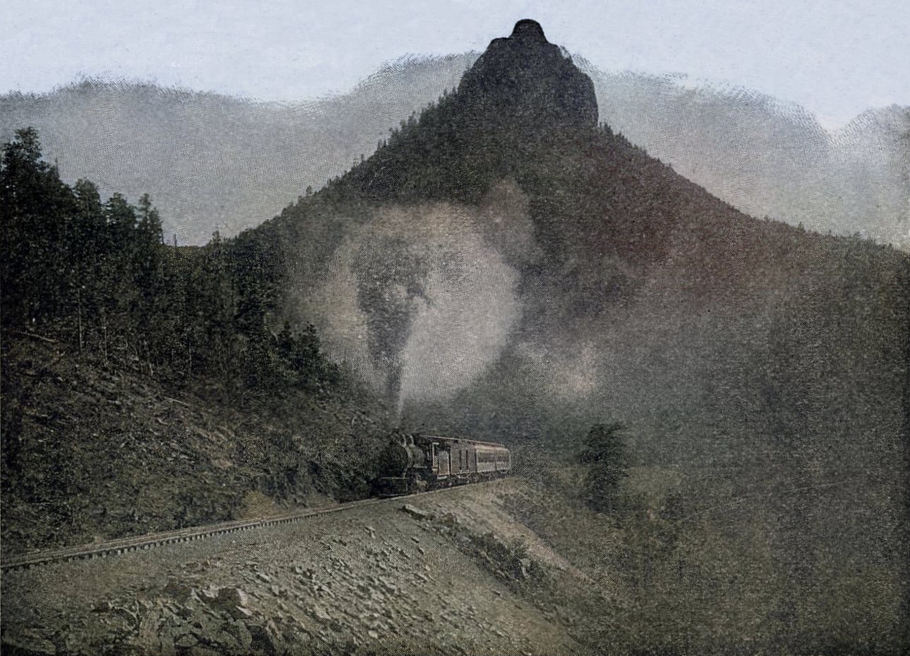
And yet while looking down on so much grandeur, there are majestic peaks that tower above you! St. Peter's Dome, as it is called, looks down from its towering height, and a magnificent dome it is. A huge mass of granite that seems to stand alone, and to guard the secrets of the depths below.
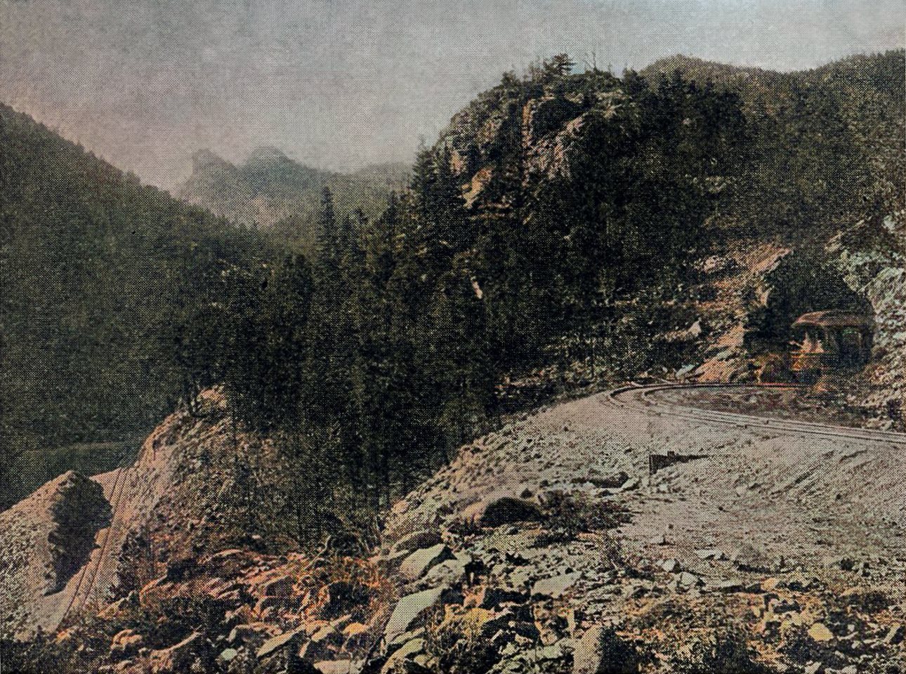
The ascent of St. Peter's Dome is a marvel of engineering skill. As the train glides along, and glory succeeds to glory, vista to vista, and canon to canon, in ever-changing but constant charm, the dizzy height is climbed apparently with so much ease that the traveler, absorbed in the entrancing surroundings, reaches the top before he is aware of it.
It seems impossible that the track we see on the opposite side of the gulch hundreds of feet above our heads should be the path we are to follow,—but a few turns, almost imperceptible, so smooth is the roadbed, and we look down on the place we have passed with equal wonder, and ask each other if that can be the track we have covered.
Ever and anon as the train climbs the side or rounds the point of each mountain peak, the matchless view of the plains is unfolded before our enraptured gaze. All description is baffled; any attempt to reproduce in words the glory of that scene must be tawdry vulgarity. There is nothing like it in the world.
St. Peter's Dome is one of the popular picnic resorts of The Short Line. Its forests of pine and spruce and its luxuriant and beautiful verdure make it an ideal spot for a day's outing. A pony and burro trail leads to the top of the dome, from which one of the grandest views in Colorado may be obtained.
Duffields.
Continuing the serpentine ascent for a few miles, we reach Duffields, 18 miles from Colorado Springs. This is the highest point from which we get the view of Colorado Springs, Broadmoor and the plains, and it is the last.
Summit.
Three miles beyond is the Summit, 10,000 feet high and the highest point reached by the road until it enters the Cripple Creek District.
As we scale the height, one of the most magnificent views imaginable bursts upon our vision. To the south, Pueblo, the "Pittsburg of the West," forty-five miles away, is plainly seen.
Rosemont.
Just beyond the summit of the range is Rosemont, a natural park surrounded and guarded by towering mountain peaks. Mount Rosa, Big Chief, San Louis and their fellows lift their heads high above this charming spot.
Saderlind.
As the train glides gently down the western slope by all kinds of mountain torrents, over creeks, through forests, four tracks, one below the other, being visible at one time, the ruggedness of the scenery is awe-inspiring. The intrepidity of the thought which conceived and the daring which achieved a railroad through such mountains almost overwhelms even the most, thoughtless.
Clyde.
At Clyde, a most wonderful exhibition of Nature's handiwork is seen. Cathedral Park is not inappropriately named. For the rocks, torn by tempest, eroded by the winds of a thousand years, rear their heads in all manner of fantastic shapes. Towers there are, and steeples innumerable; flying buttresses and vaulted caves, leaping arches and the forms of mighty buildings, hustling each other in wild disorder.
And then the coloring of the rocks; so bright, so rich, so varied, as if the angels who paint the colors of the sunset had tried their brushes on the faces of eternal hills.

CATHEDRAL PARK. This is Bridge No. 30-A, Across Bison Creek. It was 276 feet long, 56 feet high. Filled in prior to 1911.
Entering the Gold District.
And as we let our thoughts dwell upon the beauty of the scene, we find ourselves already nearing the end of our short but marvelous journey; and Bull Hill in the distance looms up to turn our attention to mines and mining and to warn us that the great Cripple Creek Gold District is at hand.
Close by stands Altman, which enjoys the distinction of being the highest incorporated town on the American continent. It is over 11,000 feet above the sea level.
Cameron.
As we approach Cameron, the first town we touch in the district, the Victor and Isabella properties, two of the big mines of Bull Hill, are in plain view. And now we enter upon what is perhaps the busiest mining district in the world. On every side we see where the restless prospector has turned the soil in his search for the precious metal.
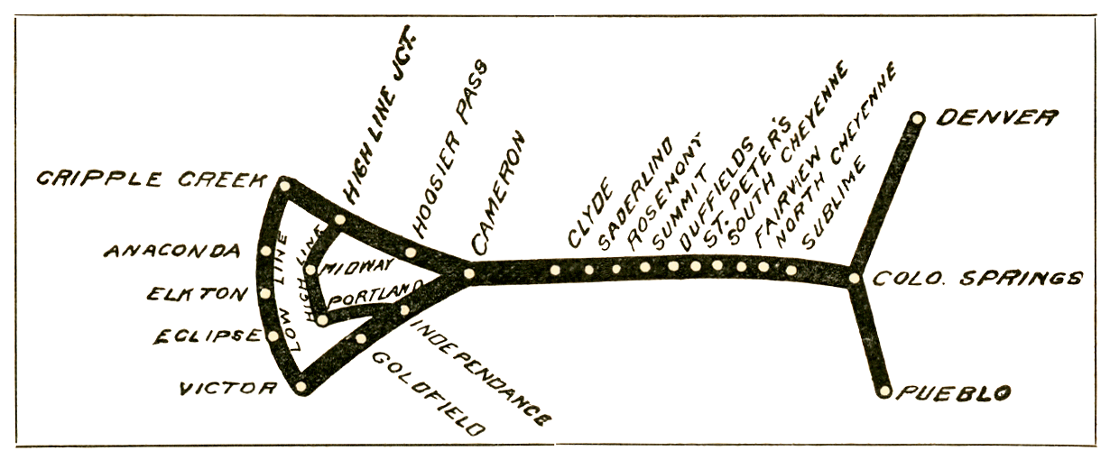
At Cameron the lines of the road diverge. One branch leads to the right, crossing over Hoosier Pass at an altitude of 10,360 feet.
As we approach Cripple Creek we pass close to the Hoosier, Moon-Anchor, Anchoria-Leland and Gold King mines, all of them famous producers.
Cripple Creek.
As the train passes over the crest of Gold Hill, the snow-capped peaks of the Sangre de Cristo range of mountains, fifty miles away, are distinctly seen on the horizon, presenting a picture of wonderful beauty. In the valley at our feet lies Cripple Creek, a thousand feet beneath us. From this point the descent is made by easy grades, until the city is reached, where this branch of the road ends.
Victor.
The other branch of the main line turns to the left at Cameron and passes through Pinnacle Park and the flourishing mining towns of Independence and Goldfield, over Victor Pass, which is about the same altitude as Hoosier Pass, and has its terminus at Victor. Here are the Portland, Stratton's Independence, Gold Coin, Strong and other famous mines.
The Electric Railway.
Between the cities of Cripple Creek and Victor two electric lines of railway, owned by this company, are operated in connection with the steam lines. These lines run to all the towns and mines not reached by the main systems.
One is known as the "Low Line," and passes through Anaconda, Arequa, Elkton, Eclipse, and other points. On this route are the Elkton, Anaconda, Doctor Jack Pot, Mary McKinney and Work mines.
The other route is the "High Line." It scales the mountains through Midway, Independence and Goldfield.
All of these are thriving mining towns, each the center of its own district. The novel and delightful trip between Cripple Creek and Victor, going by one route and returning by the other, passing within speaking distance of the great mines and shaft houses, affords a better idea of the extent of the great gold district than can be formed in any other way.
The Great Gold Camp.
Statistics are usually dry reading, but the record of this wonderful district is so remarkable that a few figures will prove interesting. But twelve years ago gold was first discovered here in paying quantities. In that brief period it has become one of the greatest gold producing regions in the world, and in rapid development and in the richness of its ores, nothing like it has ever been known before.
In twelve years the cattle ranges have been transformed into a populous district with 50,000 people.
The production to date approximates $165,000,000 in value. In 1904 it was $22,690,770.
Colorado Sunshine.
The climate of Colorado is so different from that of nearly every other region in the world in its sunshine, its dryness, its freedom from fogs, its altitude and its small daily amount of wind that it is of great value for all of those human ailments, and they are very many, which are benefited by a climatic change. It is eminently suited to consumptives.
These climatic factors have done much to increase Colorado's population, and especially of the intelligent, cultivated and well-to-do classes. The climate varies in different locations and altitudes, and here is a small list giving sun shines days in the year;
| City | Sun Shine |
|---|---|
| Colorado Springs | 304 days |
| New York | 263 days |
| Boston | 261 days |
| St. Paul | 260 days |
| Washington | 260 days |
| Chicago | 251 days |


![Photo by: William Edward Hook | Click for larger view, more info A GRANITE TUNNEL VIEW. {A View Out From Tunnel No. 4 to a Trestle on a Curve]](/04library/books/bluebook_1905-04/images/23-p21-crpd_a-granite-tunnel-view-colored_i-02590.jpg)


![Photo by: Andrew James Harlan | Click for larger view, more info Ad; Electric Circle Tour {Trolley Seen Climbing Battle Mountain Below the Portland Mine]](/04library/books/bluebook_1905-04/images/24-p22-crpd_ad-electric-circle-tour.jpg)
