-> My Collection, Also on
-> the Hathi Trust Digital Library Site; Link to article.
Source had no images, but I added one from my collection.
The Cripple Creek mining district is in the southwest part of El Paso County, Colorado, in a very rough and broken portion of the mountains. There are five towns in the district: Fremont and Cripple Creek, which have now consolidated; Barry or Anaconda, Lawrence and Mound City; and on Bull Hill, the town of Pharmacy will soon be incorporated. In addition, there are several smaller camps, situated from 3 to 6 miles from the center of greatest activity.
Among these may be mentioned Arequa, Hull's Camp, Cripple City and Midland. There are four stage roads to the camp; a county road from Florissant, which makes the staging distance about 20 miles; the toll road from Hayden Divide; a road from Colorado Springs, by way of Cheyenne, Mont., and a road from Canon City.
There are two railroads projected: The Midland Terminal, of which already 17 miles of grading is completed, and the Florence & Cripple Creek railroad, for which bids for grading and excavating have lately been received.
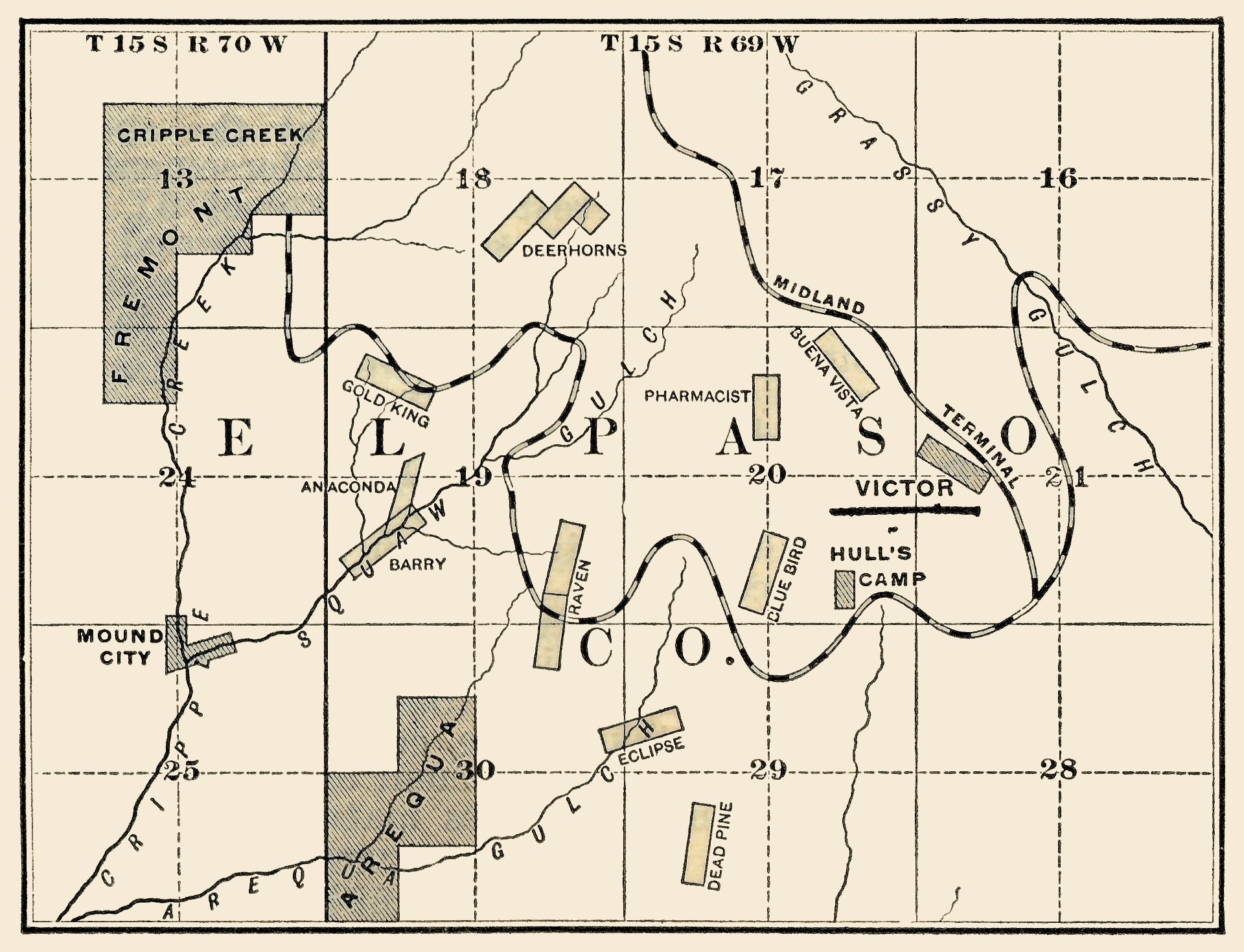
At present water works are under construction, and it is expected they will be completed in about five months. The location of the camp and the roads is shown in the map, Fig. 1. We have, ever since our connection with the camp, strongly denounced the formation of mining companies.
Dozens of claims were incorporated before they had any existence, before the assessment work was done, and stocks had to be sold to pay the miners for assessment work. Some idea may be ascertained when we state that over 330 companies were incorporated, of a nominal capital averaging $1,000,000; not to work the properties legitimately, but to handle stocks: 70% of such companies owe their inception to irresponsible scheming and designing persons of Colorado Springs.
After a long residence in this camp and careful investigation of the surrounding country and examination of nearly all the mines, we have come to the conclusion that this will be a permanent camp not a first-class mining camp, with the rich and large deposits that Leadville or the Comstock owned, but one of the best of the second-grade camps in the West.
The veins are small, as a rule, and the pay-streak narrow, but the facilities for working are good, and there are features which promise permanency.
Probably the most valuable property in Cripple Creek is the Victor, which has only recently been incorporated, but the claim was patented, and over $60,000 of gold sold and surface improvements costing fully $15,000 paid for. This mine is situated on Trachyte Mountain, or, more correctly, on the northeast side of Bull Mountain, so far the most productive one of Cripple Creek. It is about three miles from the town of Cripple Creek, at an elevation above the town of 800 to 1,000 ft.
The Victor mine is in what may be appropriately termed "pyritiferous porphyry," which runs parallel with the vein north 45° west. This pyritiferous porphyry is a fine-grained quartz and feldspar, intermingled with iron pyrites, which shows that this rock cooled very rapidly.
South of the Victor mine, about 3,000 ft. a deep shaft has unearthed a coarser grained rock known in all Western mining districts as "bird's-eye porphyry." Beyond this pyritiferous porphyry, which in this immediate vicinity is about 300 ft. wide, on the north or downhill side is a coarse-grained ferruginous-stained rock of the hardness of 2-3, which shows on every rock evidence of the percolation of water. This rock is also known as porphyry.
To the present time no mineral of value has been found in this latter kind of rock, and under ordinary circumstances but few miners would think of mining for the noble metal in it. Here, considerable work has been done in the way of shafts, tunnels and trenching.
South, or up the hill, is a large perpendicular bluff of eruptive overflow—posterior to the porphyry—andesite, in which gold has been but sparingly found, and not in quantities to mine profitably. This perpendicular bluff, known as Trachyte Mountain, rises 400 ft. above the Victor; not a little of the rock has been weathered, so much so that in the neighborhood of the Victor shaft the slide is fully 8 ft. deep.
The claim on the southwest terminates in a plateau, the head of both Wilson and Grassey Creeks and the northeast on Trachyte Mountain.
The Victor vein can be plainly traced through several other claims, the Lee, Buena Vista, Emma No. 1 and Emma No. 2. The two latter claims were located transversely across the vein; while the May has recently discovered it on the southeast.
Considerable work was done by the Calumet company 18 months ago on the Morning Star claim, a continuation of the Buena Vista, on the northwest, but without success, as subsequent developments have proved that the vein follows pretty closely the contour of the hill.
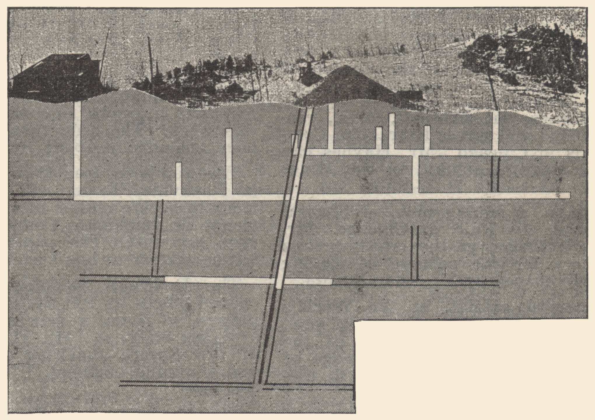
This Victor vein has been opened on and profitably mined for more than 4,000 ft., as shown in the sketch, Fig. 2.
The lode was discovered and located August 23d, 1891, being the first location on the north side of the hill. The assessment work only was done that year. When first we examined the property in March, 1892, the shaft was sunk 25 ft., the pay-streak or smelting ore being 10 in.
An assay taken at that depth yielded $78 in gold. The vein at that time could be truthfully termed a brecciated vein, small fragments of angular jasper of a heavy dull red color being intermixed. Jasper has been associated with the vein ever since its discovery to the present time, but not in such quantities as are now found on the third level.
Some samples of apparently pure jasper have assayed as high as $11,000 to the ton. In any other district this jasper would be considered valueless mineral. The richest car of ore yet shipped yielded 38 oz. gold and 5 oz. silver per ton, and consisted of a tough, plastic clay impervious to water and hardening on exposure.
The color of the richest clay is not unlike the color of a mixture of 1 lime and 2 sand. This clay is generally found on the foot and hanging walls and is free from particles of quartz crystallization as is the case elsewhere. Assays from these mud seams go as high, and even higher, than $2,500 to the ton.
The shaft is sunk to the depth of 275 ft. along the dip of the vein. There are four levels, drifting having just been commenced on the fourth, which is 240 ft. deep. In the sinking below the fourth level the vein is fully 4 ft. wide the pay streak or smelting ore being 2 ft. wide.
At the third or 140-ft. level the west drift has been extended 140 ft., while the east drift is 95 ft., with not an unproductive foot of ground. The vein varies in course and dip from north 30° west—north 70° west and dip from 60°—80°.
Two raises communicate with No. 2 level 65 ft. above, but no ore has yet been stoped. At No.2 level the vein has been opened on for more than 500 ft., and shows the continuity of the vein perfect. The same remark applies to the first level, save that here in some places the vein has been actually stoped to the "grass roots."
The vein throughout the mine will average fully 4 ft., 3 ft. of which is lower grade or milling ore yielding about 1 oz. gold per ton; while 1 ft. is high-grade or shipping ore, which will average about $250 per ton. The low-grade is not being treated at present, although there are no less than 3,000 tons on the dump and the stulls in the mines are full.
The total shipments of high-grade ore up to May 30th last were 928 tons, yielding $115,599, or an average of $124.57 per ton.


